
Geography of California
|
|
Digital-elevation-map-california.gif
The geography of California is rich and diverse. There are alpine mountains, foggy coastlines, hot deserts, and a fertile central valley. The state is home to the world's tallest (coast redwood), most massive (Giant Sequoia), and oldest (bristlecone pine) trees. It is also home to both the highest (Mt. Whitney) and lowest (Death Valley) points in the 48 contiguous states.
The state is generally divided into Northern and Southern California, although the boundary between the two is not well defined. More specifically, the state can be divided into eleven distinct natural provinces with clearly defined boundaries. They are, from north to south, the Klamath Mountains, the Cascade Range, the Modoc Plateau, the Basin and Range, the Coastal Ranges, the Central Valley, the Sierra Nevada, the Transverse Ranges, the Mohave Desert, the Peninsular Ranges, and the Colorado Desert.
| Contents |
Northern California
Klamath Mountains
The Klamath Mountains are a mountain range in northwest California and southwest Oregon, the highest peak being Thompson Peak (2744 m / 9002 ft) in Trinity County, California. They have a very varied geology, with substantial areas of serpentine and marble, and a climate characterised by cold winters with very heavy snowfall, and warm summers with limited rainfall. As a consequence of the geology, they have a unique flora including several endemic or near-endemic species, such as Lawson's Cypress (Chamaecyparis lawsoniana), Foxtail Pine (Pinus balfouriana), Brewer's Spruce (Picea breweriana) and Kalmiopsis (Kalmiopsis leachiana).
Cascade Range
Mtshasta-large.jpg
The Cascade Range is a mountainous region stretching from British Columbia in Canada down to the northern part of California. The Cascades (as they are called for short) are part of the Pacific Ring of Fire, the ring of volcanoes around the Pacific Ocean. All of the known historic eruptions in the contiguous United States have been from Cascade volcanoes. The last Cascade volcano to erupt in California was Lassen Peak, which erupted from from 1914 to 1921.
This region is located in the northeastern section of the state bordering Oregon and Nevada, north of the Central Valley and the Sierra Nevada mountain range. The area is centered on Mount Shasta, near the Trinity Alps. Mount Shasta is a dormant volcano, but there is some evidence that it or Shastina, a smaller companion, erupted in the 18th Century.
Modoc Plateau
In the northeast corner of the state lies the Modoc Plateau, an expanse of lava flows at an altitude of 4000 to 6000 ft (1200 to 1800 m) with cinder cones, juniper flats, pine forests, and seasonal lakes. Nearly 1 million acres (4,000 km²) of the Modoc National Forest lie on the plateau between the Medicine Lake Highlands in the west and the Warner Mountains in the east. The plateau supports large herds of mule deer (Odocoileus Hemionus), Rocky Mountain Elk (Cervus Canadensis), and pronghorn antelope (Antilocapra Americana). There are also several herds of wild horses on the plateau. The Clear Lake National Wildlife Refuge and Long Bell State Game Refuge are located on the plateau as well. The Lost River watershed drains the north part of the plateau, while southern watersheds either collect in basin reservoirs or flow into the large Big Sage Reservoir, which sits in the center of Modoc County.
Basin and Range
Negit_and_Paoha_islands_from_Mono_Lake_visitors_center-1000px.jpeg
To the east of the Sierra is the Barin and Range geological province, which extends into Nevada. The Basin and Range is a series of mountains and valleys (specifically horsts and grabens), caused by the extension of the Earth's crust. One notable feature of the Basin and Range is Mono Lake, which is the oldest lake in North America. The Basin and Range also contains the Owens Valley, the deepest valley in North America (more than 10,000 feet (3 km) deep, as measured from the top of Mount Whitney).
In the eastern part of the state, below the Sierra Nevada, there is a series dry lake beds that were filled with water during the last ice age (fed by ice melt from alpine glaciers but never directly affected by glaciation; see pluvial). Many of these lakes have extensive evaporite deposits that contain a variety of different salts. In fact, the salt sediments of many of these lake beds have been mined for many years for various salts, most notably borax (this is most famously true for Owens Lake and Death Valley).
In this province reside the White Mountains, which are home to the oldest living thing in the world, the bristlecone pine.
Coastal Ranges
San_Francisco_Bay_Area_Skyline_Blvd.jpg
To the west of the Central Valley lies the Coast Ranges, including the Diablo Range, just East of San Francisco, and the Santa Cruz Mountains, to the South of San Francisco. The Coast Ranges north of San Francisco become increasingly foggy and rainy. These mountains are noted for their coast redwoods, which live within the range of the coastal fog, the tallest trees on Earth.
Central Valley
California's geography is largely defined by its central feature--the Central Valley, a huge, fertile valley between the coastal mountain ranges and the Sierra Nevada. The northern part of the Central Valley is called the Sacramento Valley, after its main river, and the southern part is called the San Joaquin Valley (pronounced "san wahkeen"), after its main river. The whole Central Valley is watered by mountain-fed rivers (notably the San Joaquin, Kings, and Sacramento) that drain to the San Francisco Bay system. The rivers are sufficiently large and deep that several inland cities, notably Stockton, California, are seaports.
The southern tip of the valley has interior drainage and thus is not technically part of the valley at all. Tulare Lake, once 570 square miles and now dry and covered with agricultural fields, once filled much of the area.
Sierra Nevada

In the east of the state lies the Sierra Nevada, which runs north-south for 400 miles (600 km). The highest peak in the continental United States, Mount Whitney at 14,505 feet (4421 m), lies within the Sierra Nevada. The topography of the Sierra is shaped by uplift and glacial action.
The Sierra has 200-250 sunny days each year, warm summers, fierce winters, and varied terrain. The rare combination of rugged variety and pleasant weather leads many mountaineers to say that they are the most beautiful and accessible mountains in the world. The famous Yosemite Valley lies in the Central Sierra. The large, deep freshwater Lake Tahoe lies to the North of Yosemite. The Sierra is also home to the Giant Sequoia, the most massive trees on Earth.
These features inspired the founding of the Sierra Club and the Alpine Club, public-service clubs of mountaineers devoted to maintaining trails and lodges and organizing outings to explore the Sierra. The most famous hiking and horse-packing trail in the Sierra is the John Muir Trail, which goes from the top of Mt. Whitney to Yosemite valley, and which is part of the Pacific Crest Trail that goes from Mexico to Canada.
The three major national parks in this province are Yosemite National Park, Kings Canyon National Park, and Sequoia National Park.
Southern California
Transverse Ranges
Mount_San_Gorgonio.jpg
Southern California is separated from the rest of the state by the east-west trending Transverse Ranges, including the Tehachapi, which separate the Central Valley from the Mojave Desert. Urban Southern California intersperses the valleys between the Santa Susana Mountains, Santa Monica Mountains and San Gabriel Mountains, which range from the Pacific Coast, eastward over 100 miles (160 km), to the San Bernardino Mountains, north of Palm Springs. The highest point of the range is Mount San Gorgonio at 11,502 feet (3506 m). The San Gabriel Mountains have Mount Wilson observatory, where the redshift was discovered in the 1920s.
It is possible to surf in the Pacific Ocean and ski on a mountain during the same winter day in Southern California (but it takes planning to avoid the traffic congestion).
Mojave Desert
Badwater_Basin_from_Dante's_View-800px.JPG
There are harsh deserts in the Southeast of California. These deserts are caused by a combination of the cold offshore current, which limits evaporation, and the rain shadow of the mountains. The prevailing winds blow from the ocean inland. When the air passes over the mountains, adiabatic cooling causes most water in the air to rain on the mountains. When the air returns to sea level on the other side of the mountains, it recompresses, warms and dries, parching the deserts. When the wind blows from inland, the resulting hot dry foehn winds are called the Santa Ana Winds.
The Mojave Desert is bounded by the peninsular Tehachapi Mountains on the Northwest, together with the San Gabriel and the San Bernardino Mountains on the Southwest. These Western boundaries are quite distinct, forming the dominant pie-slice shaped Antelope Valley in Southern California. The outlines of this valley are caused by the two largest faults in California: the San Andreas and the Garlock. The Mojave Desert extends Eastward into the State of Nevada. The Mojave Desert receives less than 6 inches (150 mm) of rain a year and is generally between 3000 and 6000 feet (1000 and 2000 m) of elevation. Most of the towns and cities in the California portion of the Mojave are relatively small, except for Palmdale and Lancaster. However, some are quite famous like Barstow, a popular stop on the famous Route 66. The Mojave Desert also contains the lowest, hottest place in the Americas: Death Valley, where temperature normally approaches 120 °F (49 °C) in late July and early August.
Penninsular Ranges
The southernmost mountains of California are the Peninsular Ranges, which are East of San Diego and continue into Baja California (Mexico) in the Sierra San Pedro Martir. The Peninsular Ranges contain the Laguna Mountains, the San Jacinto Mountains, the Santa Ana Mountains and the Palomar Mountain Range, notable for its famous Palomar observatory. Mount San Jacinto's eastern shoulder has a cable tram that runs from the desert floor to nearly the top of the mountain where riders can set off to hike or go cross-country skiing.
Colorado Desert
MojaveDesert.jpg
To the east of the peninsular ranges lie the Colorado and Sonoran Deserts, which extend into Arizona and Mexico. One feature of the desert is the Salton Sea, an inland lake that was formed in 1905 when a swollen Colorado River breached a temporary canal near the Mexican border and flowed into the Salton Basin for almost two years. Today, the Salton Sea remains as California's largest lake.
Pacific Ocean
The Pacific Ocean lies to the west of California. Sea temperatures rarely exceed 65 °F (18 °C), even in summer, because of up-welling deep waters with dissolved nutrients. Therefore, most sea life in and around California more closely resembles Arctic, rather than tropical, biotopes. The sea off California is remarkably fertile, a murky green filled with fish, rather than the clear dead blue of most tropical seas. Before 1930, there was an extremely valuable sardine (herring) fishery off Monterey, but this was depleted, an event later famous as the background to John Steinbeck's Cannery Row.
Future geography
California, when only partially explored by the Spanish, was once thought to be an island, as when the southern peninsula of Baja California is approached from the Gulf of California the land appears to the west. It is expected, through the motions of plate tectonics that the sea floor spreading now acting in the Gulf of California (also known as the Sea of Cortez) will eventually extend through Southern California and along the San Andreas fault to below San Francisco, finally forming a long island in less than 150 million years. (For comparison, this is also the approximate age of the Atlantic Ocean.) Predictions suggest that this island will eventually collide with Alaska after an additional 100 million years.
See also


External links
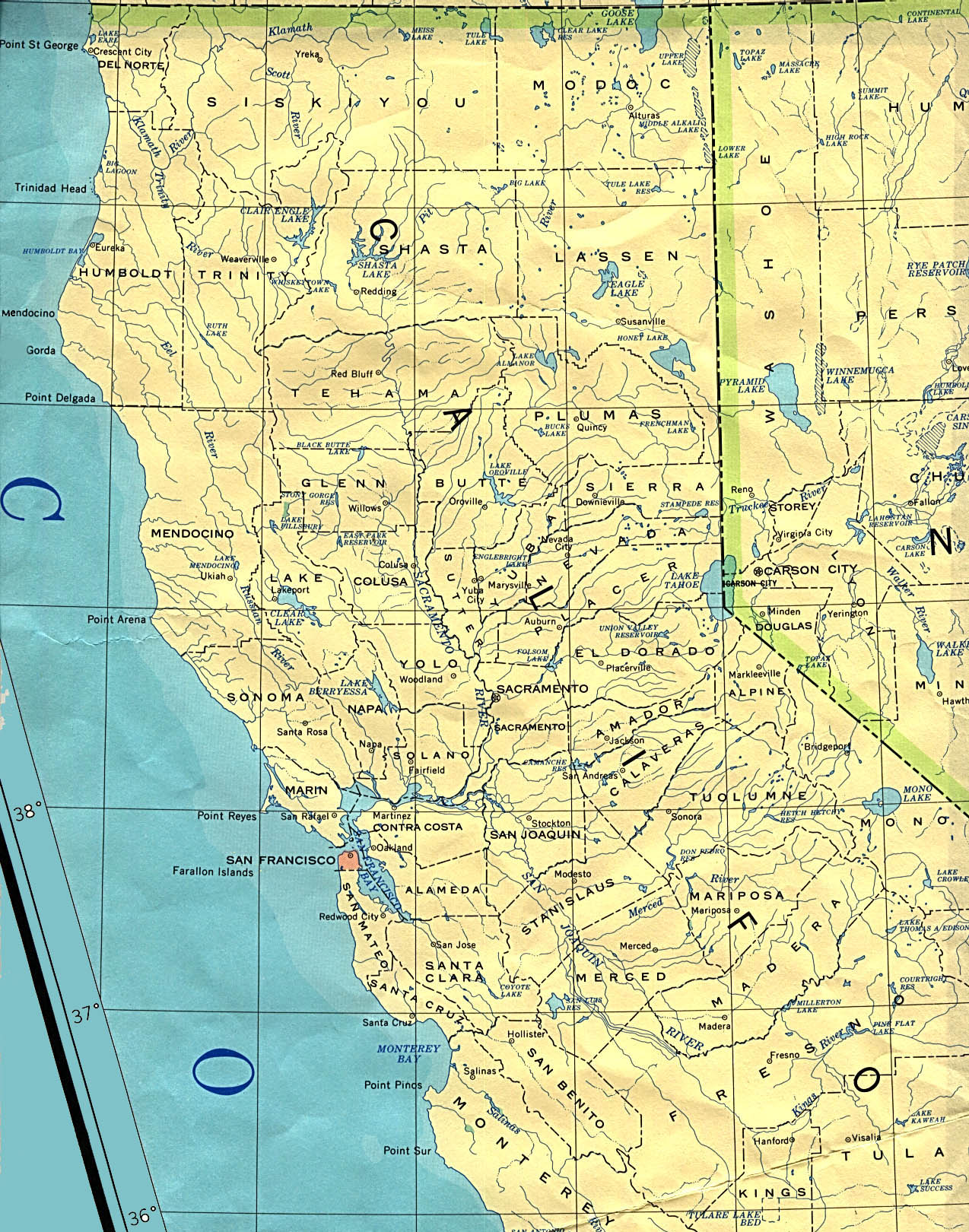
- Map of Northern California (http://www.lib.utexas.edu/maps/united_states/california_north_90.jpg)
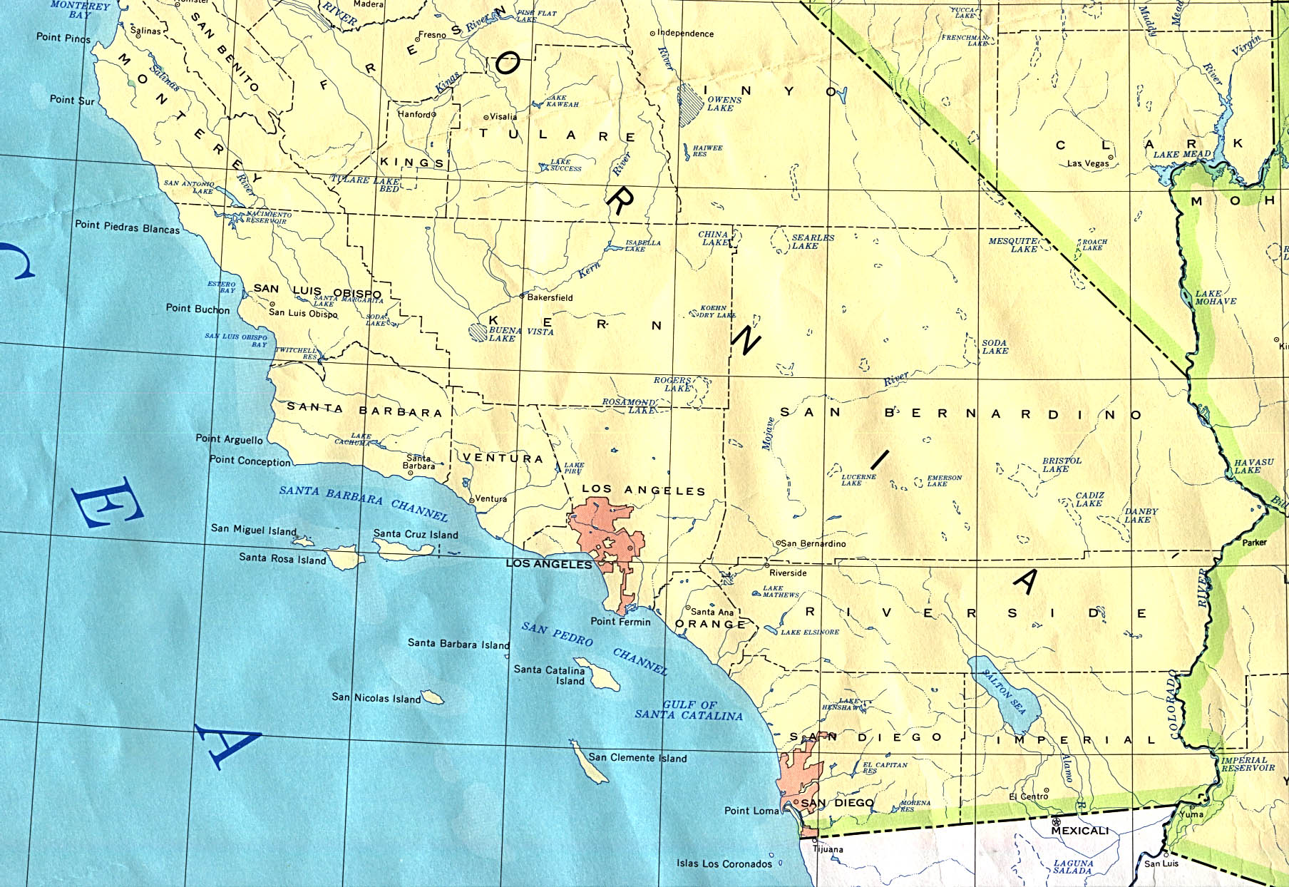
- Map of Southern California (http://www.lib.utexas.edu/maps/united_states/california_south_90.jpg)