Surat Thani Province

Surat Thani
สุราษฎร์ธานี
Statistics
Capital:Surat Thani
Area:12,891.5 km²
Ranked 6th
Inhabitants:951,517 (2004)
Ranked 21st
Pop. density:73.80 inh./km²
Ranked 65th
ISO 3166-2:TH-84
Map
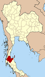
Map of Thailand highlighting Surat Thani Province

Surat Thani (often in short Surat, Thai สุราษฎร์ธานี) is the largest of the southern provinces (changwat) of Thailand, on the eastern shore of the Gulf of Thailand. Surat Thani means City of Good People, the title given to the city by King Vajiravudh (Rama VI).

Contents

Geography

Neighboring provinces are (from north clockwise) Chumphon, Nakhon Si Thammarat, Krabi, Phang Nga and Ranong.

Geographically the center of the province is the coastal plain of the Tapi river, mostly grassland and some mangrove. In the west are limestone mountains mostly covered with forests. The Khao Sok National Park is located in these mountains. To the east the hills of the Nakhon Sri Thammarat (or Bantat) mountain range start to rise, protected in the Tai Rom Yen National Park. Many islands in the Gulf of Thailand belong to the district, including the tourist islands Ko Samui, Ko Pha Ngan, Ko Tao, as well as the Ko Angthong marine national park. The main rivers of the Surat Thani province are Tapi River and Phum Duang River, which both drain into the Bandon Bay.

Economy

The main agricultural products of the province are coconut and rambutan. The coconuts are often picked from the tree by specially trained monkey, mostly Pig-tailed Macaques (Macaca nemestrina). The monkey school of late Somporn Saekow is the most famous training center for these monkeys. The rambutan trees were first planted in Surat Thani in 1926 by the Chinese Malay Mr. K. Vong in Ban Na San. An annual rambutan fair is held in beginning of August, including a parade of highly decorated floats on the Tapi river.

Transportation

The province is crossed by the southern railway, with the main railway station located at Phunphin. Parallel to the railway runs the Asian Highway 2. Two regional airports are located in the province - Surat Thani International Airport in Phunphin and Ko Samui airport on Ko Samui. The islands Ko Samui und Ko Phan Ngan are connected with the mainland by ferries, which mostly start at Don Sak.

History

The area of Surat Thani was already inhabited in prehistoric times by Semang and Malayan tribes. Founded in the 3rd century, until the 13th century the Srivijaya kingdom dominated the Malay Peninsula and much of the island of Java from there. The city Chaiya contains several ruins from Srivijaya times, and was probably a regional capital of the kingdom. Some Thai historians even claim that it was the capital of the kingdom itself for some time, but this is generally disputed. Wiang Sa was another main settlement of that time.

After the fall of the Srivijaya it was divided into the cities Chaiya and Thatong (now Kanchanadit). While Chaiya was administrated directly from the capital, Thatong was controlled by the Nakhon Si Thammarat kingdom. In 1899 they were merged into the province Chaiya. In 1915 the court of the Monthon Chumphon was moved to Bandon, which received its new name Surat Thani on July 29 1915 during a visit of King Vajiravudh (Rama VI). In 1933 the monthon was dissolved, so the province became the first level administrative subdivision.

Symbols

Missing image
Seal_Surat_Thani.png
Provincial seal

The seal of the province shows the pagoda of Phra Boromathat Chaiya, which is believed to have been built 1200 years ago. The flag of the province also shows the pagoda in middle, placed on a vertically split flag with red color in top and yellow in bottom.

The provincial symbolic flower is the Bua Phut (Rafflesia kerrii), a parasitic plant with one of the biggest flowers of all plants. The provincial tree is the Ton Kiam (Cotylelobium melanoxylon).

The provincial slogan is เมืองร้อยเกาะ เงาะอร่อย หอยใหญ่ ไข่แดง แหล่งธรรมะ, which translates to City of 100 islands, delicious rambutan, big shells and red eggs, center of Buddhism. Red eggs are a local culinary speciality of pickled duck eggs, while the big shells refer to the plenty of seafood available. Center of Buddhism refers to the pagoda of Chaiya.

Administrative divisions

Missing image
Surat_Thani_Amphoe.png
Map of Surat Thani

The province is subdivided into 18 districts (Amphoe) and one sub-district (King Amphoe). The districts are further subdivided into 131 communes (tambon) and 1028 villages (mubaan).

Amphoe King Amphoe
  1. Mueang Surat Thani
  2. Kanchanadit
  3. Don Sak
  4. Ko Samui
  5. Ko Pha Ngan
  6. Chaiya
  7. Tha Chana
  8. Khiri Ratthananikhom
  9. Ban Ta Khun

  1. Phanom
  2. Tha Chang
  3. Ban Na San
  4. Ban Na Doem
  5. Khian Sa
  6. Wiang Sa
  7. Phrasaeng
  8. Phunphin
  9. Chai Buri

  1. Wiphawadi

External links

Template:Commons


edit  (https://academickids.com:443/encyclopedia/index.php?title=Template:Provinces_of_Thailand&action=edit) Provinces of Thailand Flag of Thailand
North: Chiang Mai | Chiang Rai | Kamphaeng Phet | Lampang | Lamphun | Mae Hong Son | Nakhon Sawan | Nan | Phayao | Phetchabun | Phichit | Phitsanulok | Phrae | Sukhothai | Tak | Uthai Thani | Uttaradit
North-East: Amnat Charoen | Buriram | Chaiyaphum | Kalasin | Khon Kaen | Loei | Maha Sarakham | Mukdahan | Nakhon Phanom | Nakhon Ratchasima | Nongbua Lamphu | Nong Khai | Roi Et | Sakon Nakhon | Sisaket | Surin | Ubon Ratchathani | Udon Thani | Yasothon
Central: Ang Thong | Ayutthaya | Bangkok | Chachoengsao | Chainat | Kanchanaburi | Lopburi | Nakhon Nayok | Nakhon Pathom | Nonthaburi | Pathum Thani | Prachinburi | Phetchaburi | Prachuap Khiri Khan | Ratchaburi | Sa Kaeo | Samut Prakan | Samut Sakhon | Samut Songkhram | Saraburi | Sing Buri | Suphanburi
South: Chumphon | Krabi | Nakhon Si Thammarat | Narathiwat | Pattani | Phang Nga | Phattalung | Phuket | Ranong | Satun | Songkhla | Surat Thani | Trang | Yala
East: Chanthaburi | Chonburi | Rayong | Trat
de:Surat Thani (Provinz)

fr:Province de Surat Thani ja:スラートターニー県 ms:Wilayah Surat Thani nl:Changwat Surat Thani th:จังหวัดสุราษฎร์ธานี

Navigation

  • Art and Cultures
    • Art (https://academickids.com/encyclopedia/index.php/Art)
    • Architecture (https://academickids.com/encyclopedia/index.php/Architecture)
    • Cultures (https://www.academickids.com/encyclopedia/index.php/Cultures)
    • Music (https://www.academickids.com/encyclopedia/index.php/Music)
    • Musical Instruments (http://academickids.com/encyclopedia/index.php/List_of_musical_instruments)
  • Biographies (http://www.academickids.com/encyclopedia/index.php/Biographies)
  • Clipart (http://www.academickids.com/encyclopedia/index.php/Clipart)
  • Geography (http://www.academickids.com/encyclopedia/index.php/Geography)
    • Countries of the World (http://www.academickids.com/encyclopedia/index.php/Countries)
    • Maps (http://www.academickids.com/encyclopedia/index.php/Maps)
    • Flags (http://www.academickids.com/encyclopedia/index.php/Flags)
    • Continents (http://www.academickids.com/encyclopedia/index.php/Continents)
  • History (http://www.academickids.com/encyclopedia/index.php/History)
    • Ancient Civilizations (http://www.academickids.com/encyclopedia/index.php/Ancient_Civilizations)
    • Industrial Revolution (http://www.academickids.com/encyclopedia/index.php/Industrial_Revolution)
    • Middle Ages (http://www.academickids.com/encyclopedia/index.php/Middle_Ages)
    • Prehistory (http://www.academickids.com/encyclopedia/index.php/Prehistory)
    • Renaissance (http://www.academickids.com/encyclopedia/index.php/Renaissance)
    • Timelines (http://www.academickids.com/encyclopedia/index.php/Timelines)
    • United States (http://www.academickids.com/encyclopedia/index.php/United_States)
    • Wars (http://www.academickids.com/encyclopedia/index.php/Wars)
    • World History (http://www.academickids.com/encyclopedia/index.php/History_of_the_world)
  • Human Body (http://www.academickids.com/encyclopedia/index.php/Human_Body)
  • Mathematics (http://www.academickids.com/encyclopedia/index.php/Mathematics)
  • Reference (http://www.academickids.com/encyclopedia/index.php/Reference)
  • Science (http://www.academickids.com/encyclopedia/index.php/Science)
    • Animals (http://www.academickids.com/encyclopedia/index.php/Animals)
    • Aviation (http://www.academickids.com/encyclopedia/index.php/Aviation)
    • Dinosaurs (http://www.academickids.com/encyclopedia/index.php/Dinosaurs)
    • Earth (http://www.academickids.com/encyclopedia/index.php/Earth)
    • Inventions (http://www.academickids.com/encyclopedia/index.php/Inventions)
    • Physical Science (http://www.academickids.com/encyclopedia/index.php/Physical_Science)
    • Plants (http://www.academickids.com/encyclopedia/index.php/Plants)
    • Scientists (http://www.academickids.com/encyclopedia/index.php/Scientists)
  • Social Studies (http://www.academickids.com/encyclopedia/index.php/Social_Studies)
    • Anthropology (http://www.academickids.com/encyclopedia/index.php/Anthropology)
    • Economics (http://www.academickids.com/encyclopedia/index.php/Economics)
    • Government (http://www.academickids.com/encyclopedia/index.php/Government)
    • Religion (http://www.academickids.com/encyclopedia/index.php/Religion)
    • Holidays (http://www.academickids.com/encyclopedia/index.php/Holidays)
  • Space and Astronomy
    • Solar System (http://www.academickids.com/encyclopedia/index.php/Solar_System)
    • Planets (http://www.academickids.com/encyclopedia/index.php/Planets)
  • Sports (http://www.academickids.com/encyclopedia/index.php/Sports)
  • Timelines (http://www.academickids.com/encyclopedia/index.php/Timelines)
  • Weather (http://www.academickids.com/encyclopedia/index.php/Weather)
  • US States (http://www.academickids.com/encyclopedia/index.php/US_States)

Information

  • Home Page (http://academickids.com/encyclopedia/index.php)
  • Contact Us (http://www.academickids.com/encyclopedia/index.php/Contactus)

  • Clip Art (http://classroomclipart.com)
Toolbox
Personal tools