Shropshire
|
|
| Shropshire | |
|---|---|

| |
| Geography | |
| Status: | Ceremonial & (smaller) Administrative County |
| Region: | West Midlands |
| Area: - Total - Admin. council - Admin. area | Ranked 13th 3,487 km² Ranked 14th 3,197 km² |
| Admin HQ: | Shrewsbury |
| ISO 3166-2: | GB-SHR |
| ONS code: | 39 |
| NUTS 3: | UKG22 |
| Demographics | |
| Population: - Total (2003 est.) - Density - Admin. council - Admin. pop. | Ranked 42nd 447,033 128 / km² Ranked 34th 286,745 |
| Ethnicity: | 97.3% White 1.2% S.Asian |
 Badge of Shropshire County Council | |
| Politics | |
| Shropshire County Council http://www.shropshire-cc.gov.uk/ | |
| Executive: | Conservative |
| MPs: | Mark Pritchard, Philip Dunne, Daniel Kawczynski, Owen Paterson, David Wright |
| Districts | |
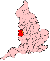
Shropshire (abbreviated Salop or Shrops) is a county in the West Midlands region of England, bordering Cheshire, Staffordshire, Worcestershire, Herefordshire, and the Welsh counties of Powys and Clwyd.
Shropshire is one of England's most rural counties. The county town is Shrewsbury, although the new town of Telford is the largest town. Also in this rural county is Coalbrookdale, where the Industrial Revolution started, Ironbridge, where the world's first iron bridge was constructed and Ditherington, where the world's first iron framed building was built. (See the "cradle of industry" section below).
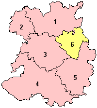
The ceremonial county of Shropshire is now split up into the administrative county of Shropshire and the unitary authority of Telford and Wrekin borough. Shropshire, the administrative county, is then split up into five districts - Shrewsbury and Atcham borough, Oswestry borough, North Shropshire district, South Shropshire district and Bridgnorth district. The administrative county is then further sub-divided into parishes, except for the town of Shrewsbury. The area covered by the ceremonial county has not changed for centuries (other than the removal of several exclaves in other counties) - see traditional counties of England.
A 2005 estimate of the population of the administrative county of Shropshire was put at 286,400 - making the county the smallest two-tier administration in England.
The county was called Salop in legal documents for some centuries, a name deriving from 'Salopesbiry', an older name for the county town, Shrewsbury. When a council for the county was set up in 1888, it was called 'Salop County Council'. The name was never popular, and the council renamed itself 'Shropshire County Council' in 1980. However, the term "Salopian", derived from "Salop", is still used to mean "from Shropshire".
| Contents |
Cradle of Industry
Quite why this remote, rural county on the Welsh border became the birthplace of the Industrial Revolution is mystifying to many people. The reason, however, is mainly due to Shropshire's diverse geology. Shropshire is the "geological capital" of the UK, as just about every rock type in Northern Europe is found within its borders, as are coal, lead, copper and iron ore deposits. In addition to this, the River Severn flows through the county and has been used for the transportation of goods and services for centuries.
Geography
Geographically, Shropshire is divisible into two distinct halves - North and South.
North Shropshire
Politically - Oswestry district, North Shropshire district, Shrewsbury and Atcham borough and the unitary borough of Telford and Wrekin.
The North Shropshire Plain is an extension of the flat and fertile Cheshire Gap. It is here that most of the county's large towns, and population in general, is to be found. Shrewsbury at the centre, Oswestry to the north west, Whitchurch to the north, Market Drayton to the north east and the Telford connurbation (Telford, Wellington, Newport, Oakengates, Donnington and Shifnal) to the east. The land is fertile and agriculture remains a major feature of the landscape and the economy. The River Severn runs through the lower half of the Northern area, through Shrewsbury and the Ironbridge Gorge, before heading south to Bridgnorth.
The area around Oswestry has more rugged geography than the North Shropshire Plain and the western half is over an extension of the Wrexham Coalfield and there are also copper deposits on the border with Wales. Mining of stone and sand aggregates is still going on in North Shropshire, notably on Haughmond Hill, near Bayston Hill and around the village of Condover. Other primary industries, such as forestry and fishing, are to be found too.
The A5 and M54 run from Wolverhampton (to the east of the county) across to Telford, around Shrewsbury and then north west to Oswestry, before heading north into Wales in the Wrexham area. This is an important artery and the corridor is where most of Shropshire's modern commerce and industry is found, notably in Telford new town. There are also a number of railway lines crossing over the area, which centre at Shrewsbury. To the south west of Telford, near the Ironbridge Gorge, is Buildwas Power Station.
The new town of Telford is built on a former industrial area centred on the East Shropshire Coalfield. There are still many colliery heaps to be found in the area, as well as disused mine shafts. This industrial heritage is an important tourist attraction, as is seen by the growth of museums in the Ironbridge, Coalbrookdale and Jackfield area. Blists Hill museum and historical (Victorian era) village is a major tourist attraction as well as the Iron Bridge itself.
South Shropshire
Politically - South Shropshire district and Bridgnorth district.
South Shropshire is more rural, with fewer settlements and no large towns, and its landscape differs greatly than that of North Shropshire. The area is dominated by hill ranges and valleys, forests and glens, and other natural features. Farming is more pastural than the arable found in the north of the county. The only substantial towns are Ludlow, Bridgnorth and Church Stretton.
The A49 is the main road through the area, running north to south, from Shrewsbury to Herefordshire. A railway line runs through the area on the same route as the A49 with stations at Church Stretton, Craven Arms and Ludlow. Infrastructure is generally quite poor in the south of the country, but this is due mainly because of the low population density. The Severn Valley Railway runs from Bridgnorth into Worcestershire.
Church Stretton is known as "Little Switzerland" due to its valley location and character. Nearby are the old mining communities on the Clee Hills, notable geological features in the Onny Valley and Wenlock Edge and fertile farmland in the Corve Dale. The River Teme drains this part of the county, before flowing into Worcestershire to the South.
South West Shropshire, or simply "Clun", is a little known and remote part of the county, with Clun Forest, Offa's Dyke and the River Clun. The small towns of Clun and Bishop's Castle are in this area. The countryside here is very rural and is in parts wild and forested. To the South of Clun is the Welsh town of Knighton.
Towns and villages
See the list of places in Shropshire.
Places of interest
- Attingham Park, (Atcham)
- Blists Hill, (preserved 19th century industrial/victorian age community)
- Boscobel House, (on border with Staffordshire)
- Brown Clee Hill, (highest peak in Shropshire)
- Burford House
- Caer Caradoc, (near Church Stretton)
- Cardingmill Valley, (Church Stretton)
- Haughmond Hill, (forest park on the edge of Shrewsbury with the medieval Haughmond Abbey ruins)
- Hawkstone Park, (large rural park and follies in north Shropshire)
- Hopton Castle, (scene of a Civil War massacre)
- The Ironbridge, (the worlds first iron bridge)
- Langley Chapel
- The Long Mynd, (means "long mountain", overlooks Church Stretton)
- Ludlow Castle
- Mitchells Fold, (a bronze age stone circle)
- Moreton Corbet Castle
- Offa's Dyke Path, a long distance footpath
- Shropshire Hills AONB
- Shropshire Union Canal
- Snailbeach, (a historic lead mining village)
- The Stiperstones, (mountainous ridge near Pontesbury, including the "Devil's Chair")
- Stokesay Castle
- Titterstone Clee Hill, (hill near Ludlow, ex-coalmining and famed for the unusual accent of the locals)
- Wenlock Edge, (a long wooded ridge and the geological capital of the UK)
- Whittington Castle
- Wroxeter, (a ruined Roman city and legionary fortress)
Famous People
- Robert Clive "Clive of India"
- Lords and Ladies Craven (of Stokesay Castle)
- Abraham Darby
- Charles Darwin
- William Farr
- George Jeffreys of Wem, (infamous judge)
- Len Murray, (former head of the T.U.C)
- Wilfred Owen
- Edmund Plowden (1518-1585)—legal scholar and theorist
- Sir Edmund Plowden (1590-1659)—Proprietor, Earl Palatine and Governor of New Albion
- Barbara Pym
- T'Pau, pop group
- Sir Philip Sidney
- Mary Webb (1881-1927), authoress
- Matthew Webb, (first man to swim the English Channel)
- Billy Wright
- Norton I, Emperor of the United States of America
Also, British poet A.E. Housman used Shropshire as the setting for many of the poems in his first book, A Shropshire Lad.
Politics
Shropshire has five constituencies, four of which returned Conservative MPs at the 2005 general election and one, Telford, returned a Labour MP. This is a marked change from the 2001 general election result, where the county returned only one Conservative, three Labour and a Liberal Democrat MP.
- David Wright, Labour, Telford
- Owen Paterson, Conservative, North Shropshire (covering the North Shropshire district and Oswestry borough)
- Philip Dunne, Conservative, Ludlow (covering the South Shropshire and Bridgnorth districts)
- Daniel Kawczynski, Conservative, Shrewsbury and Atcham
- Mark Pritchard, Conservative, The Wrekin (covering Telford and Wrekin borough, minus Telford and including a small area of Bridgnorth district)
In 2005 there was also a County Council election and the Conservatives gained overall control of the administrative county. Telford and Wrekin Unitary Authority remains under Labour control.
Trivia
Oswestry Football Club play in the Welsh League.
Shropshire holds the record for the coldest temperature recorded in England and Wales (weather wise). This was set on January 10, 1982, in Edgmond at -26.1 C. The following day the coldest daytime maximum temperature recorded in England occured in the county, at -11.3 C.
Shrewsbury has the tallest town crier in the world, at 7ft 2in, and now also the tallest MP in the United Kingdom - Daniel Kawczynski is 6ft 8.5in tall.
The ceremonial county of Shropshire is the United Kingdom's largest inland (surrounded entirely by land) county.
See also
Railways of Shropshire
Etymological list of counties
- Secret Shropshire (http://www.secretshropshire.org.uk) - Document archives relating to Shropshire are being made available online, over 10,000 images including maps, photographs of scenery, buildings, famous people and natural history, sketches, and writings.
- Shropshire Star (http://www.shropshirestar.com) - Local newspaper.
- BBC Shropshire history (http://www.bbc.co.uk/shropshire/history/index.shtml) - BBC Shropshire's history page.
- Fords in Shropshire (http://vamp.idlers.org/~jaffa/shropshire.htm) - Listing of all fords in Shropshire, including photos.
- Pubs in Shropshire (http://www.shropshirestar.com/features/whatson/diningout/public_houses.php) - A growing database on the public houses of the county, from the Shropshire Star.
- Shropshire aerial photos (http://www.webbaviation.co.uk/shropshire_gallery.htm) - Fantastic website with many photos of places in Shropshire, taken from the air
| United Kingdom | England | Ceremonial counties of England | 
|
|
Bedfordshire | Berkshire | City of Bristol | Buckinghamshire | Cambridgeshire | Cheshire | Cornwall | Cumbria | Derbyshire | Devon | Dorset | Durham | East Riding of Yorkshire | East Sussex | Essex | Gloucestershire | Greater London | Greater Manchester | Hampshire | Herefordshire | Hertfordshire | Isle of Wight | Kent | Lancashire | Leicestershire | Lincolnshire | City of London | Merseyside | Norfolk | Northamptonshire | Northumberland | North Yorkshire | Nottinghamshire | Oxfordshire | Rutland | Shropshire | Somerset | South Yorkshire | Staffordshire | Suffolk | Surrey | Tyne and Wear | Warwickshire | West Midlands | West Sussex | West Yorkshire | Wiltshire | Worcestershire |

